
CONSTRUCTION & INDUSTRIAL
Drone Services
PROFESSIONAL
SERVICES

UAV
INSPECTION

MAPPING &
DATA ACQUISITION

PROGRESS
MONITORING

SAFE & LEGAL
OPERATIONS

Insured
SmartDrones carries $3 million in liability insurance, which is 30 times the minimum amount previously required by Transport Canada.

Regulatory
Complaint
One of the additional unique services that is included in our pricing is ensuring regulatory compliance. We are the only drone company in Canada that has an experienced regulatory lawyer on staff that looks after obtaining the necessary approvals.

Experienced
All of our pilots are fully trained, certified, and experienced in providing our inspection and progress monitoring services to numerous construction companies while maintaining our zero incident track-record.
UAV's WITH
LEADING EDGE
SAFTEY SYSTEMS
Our fleet of drones is equipped with the latest Ballistic Parachute Technology reducing risk and increasing the overall safety of our operations.

SEE OUR SYSTEMS IN ACTION


UAV INSPECTION
Avoid the risks involved with traditional methods of inspection by replacing the human risk factor with SmartDrones’ aerial inspection service. Our drones are capable of inspecting dangerous or hard to reach areas much safer and more efficiently than the previous procedures.

Our state of the art sensors allow us to capture high resolution imagery that can be used to examine critical details of infrastructure.
FASTER, SAFER, & CHEAPER
THAN TRADITIONAL METHODS
3 cups
Blueberries
3 cups
Flour
1 cup
Sugar
2 tbsp.
Salt
1½ cups
Butter
> Significantly Reduced Human Risk
> More Cost Effect Than Traditional Methods
> Reduces Shutdown Times with Efficient Data Collection
> Perfect for Well Sites, Refineries, Transmission Lines, Pipelines, Ect


Keep tabs on how your project is coming along with SmartDrones’ aerial progress monitoring services. We can accommodate a variety of inspection schedules from weekly to quarterly. Volume discounts are offered on projects that require a higher quantity of flights.
PROGRESS
MONITORING

0
Incidents in our operational history


Our pilots and flight platforms are trained and equipped to conduct indoor operations safely and efficiently for any interior inspection or interior progress monitoring.
INDOOR
OPERATIONS
MONITOR ALL STAGES OF CONSTRUCTION
![shutterstock_784543489-[Converted].png](https://static.wixstatic.com/media/b1ad3c_46720e5ed3b14564a7590a5470d219bd~mv2.png/v1/crop/x_0,y_0,w_478,h_272/fill/w_389,h_220,al_c,q_85,usm_0.66_1.00_0.01,enc_avif,quality_auto/shutterstock_784543489-%5BConverted%5D.png)
![shutterstock_784543489-[Converted].png](https://static.wixstatic.com/media/b1ad3c_46720e5ed3b14564a7590a5470d219bd~mv2.png/v1/crop/x_0,y_288,w_478,h_287/fill/w_391,h_231,al_c,q_85,usm_0.66_1.00_0.01,enc_avif,quality_auto/shutterstock_784543489-%5BConverted%5D.png)
![shutterstock_784543489-[Converted].png](https://static.wixstatic.com/media/b1ad3c_46720e5ed3b14564a7590a5470d219bd~mv2.png/v1/crop/x_0,y_657,w_478,h_343/fill/w_385,h_277,al_c,q_85,usm_0.66_1.00_0.01,enc_avif,quality_auto/shutterstock_784543489-%5BConverted%5D.png)


3,000,000+
Sq Ft. Of Interior
Inspection's Flown


Our drone and camera systems are designed for long range transmission, making them perfect for acquiring footage of large scale linear developments. We have experience gather inspection footage for various linear construction projects including pipeline & power lines ROW's, transportation projects.
LINEAR PROJECTS
> PIPELINE ROWS > POWER LINES
> TRANSPORTATION > CONSTRUCTION
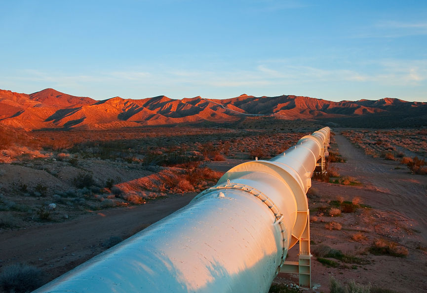
250 km+
of ROW Flown


SmartDrones utilizes our aerial camera systems alongside photogrammetry techniques to create precise and measurable 3D maps and models. These 3D models and maps of construction sites, landscapes, or structures are created using millions of data points that can be used to obtain accurate volumetric assessments and precise measurements.
MAPPING &
DATA ACQUISITION
GATHER ACCURATE
ACTIONABLE DATA
Efficient Capture
Our drone are capable of rapidly gathering imagery from large areas. This allows us to efficiently map projects of all sizes.


Precision
Our drone photogrammetry techniques utilizes the metadata from our drone’s GPS system and powerful computer hardware to create 3D models and maps with an accuracy of 1-3cm GSD. (Ground Sample Distance)


Measurable
The precise data captured in our 3D models allows us to provide measurements of height, distance, and volume. Being able to take these measurements anywhere within our models makes them perfect for volumetric surveying and serving as a record for potential disputes in the construction process..
Click and drag the slider on the centre of the image below to view the millions of data points used to create our measurable 3D maps and models.
DATA RICH 3D MODELS
Easily export digital maps and 3D models to industry-compatible formats for further analysis or reporting.
> Full-Color Point Cloud (.las, .laz, .ply, .xyz)
> Orthomosaic (GeoTiff, .tif, .kml)
> Contour Lines (.shp, .dxf, .pdf)
> DSM- Digital Surface Model (GeoTiff, .tif, .xyz, .las, .laz)
> 3D Textured Mesh (.ply, .fbx, .dxf, .obj, .pdf)
> Index Maps (GeoTiff, .tif, .shp)
UAV's PROVIDE AN EFFECTIVE METHOD TO INSPECT LARGE SCALE LINEAR-DEVELOPMENTS.
SmartDrones is experienced in filming vast stretches of linear projects throughout their various stages of construction . Whether it is for planning, inspections, or litigation, SmartDrones can perform footage and imagery as a cost-effective alternative to the traditional means via a helicopter inspection.
> Long Range Flights
> Faster Than Ground Inspections
> More Cost Effective than Manned Aircraft
> Ability to Zoom on Particular Features
3 cups
Blueberries
3 cups
Flour
1 cup
Sugar
2 tbsp.
Salt
1½ cups
Butter
